
2023 Vital Signs Report
Feature Report

The UNESCO Man and the Biosphere Programme (MAB) requires each biosphere region to have appropriate zonation that includes:
The land designations and zonation have evolved over the years due to various land use planning and management changes. In 2024, Ahousaht and Tla-o-qui-aht First Nations leadership, along with the provincial government engaged in the conversion of approximately 77,000 hectares of Tree Farm License 54 (TFL 54) into conservancies in Clayoquot Sound. Our latest zonation map was created in 2020 and the CBT will be updating this map in the years to come, to reflect changes in the conservation landscape.
Please note that we are currently updating our maps and zonation following the ʕaaḥuusʔatḥ (Ahousaht) Nation’s decision, announced on August 8, 2025, to resign from being a part of the Clayoquot Sound Biosphere Region.

In 2000, the Clayoquot Sound Biosphere met the UNESCO zonation requirements with a configuration of zones shown here:
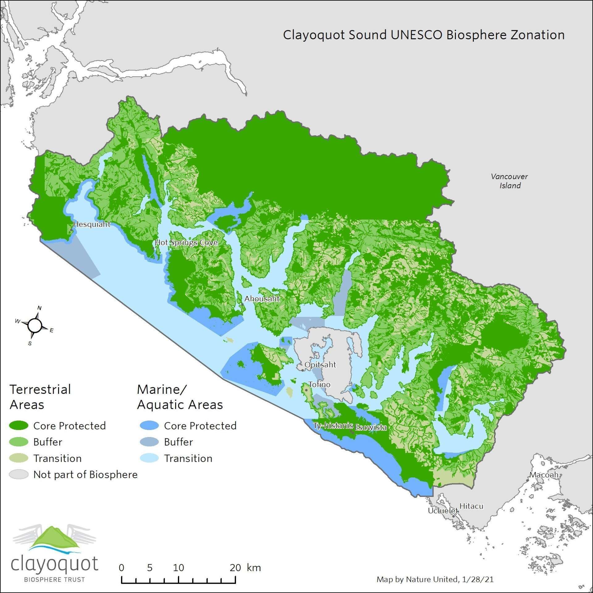
Please note that this map was created in 2021. We are currently updating our maps and zonation following the ʕaaḥuusʔatḥ (Ahousaht) Nation’s decision, announced on August 8, 2025, to resign from being a part of the Clayoquot Sound Biosphere Region.
In 2008, the land designations legally changed within the Clayoquot Sound Biosphere. New watershed plans mapped and designated areas set aside as regions to protect a range of values including: hydroriparian resources, sensitive soils and unstable terrain, red- and blue-listed species, forest-interior conditions in late successional forests, cultural values, scenic and recreation values, and representative ecosystems.
The 2008 watershed plans also mapped and designated:
Our 2020 zonation map shown here reflects these designations.
These 2008 watershed plans significantly impacted the Clayoquot Sound Biosphere zonation. Based on the recommendations of the Clayoquot Scientific Panel and the inclusion of the nuučaan̓uł (Nuu-chah-nulth) First Nations as major participants in the planning process, completion of the watershed plans represent efforts that meet the MAB’s zonation requirements.
The watershed plan reserves, harvestable areas, and special management zones altered the actual amount of area within the core area, buffer zone, and transition zone within the Clayoquot Sound Biosphere in comparison to the spatial configuration from 2000. These land use designations result in:
The following table depicts areas (ha) within each terrestrial zone of the Clayoquot Sound Biosphere after allocating:
Terrestrial Zone | Area (ha) in Nomination Document | Area (ha) in CSBR Periodic Review 2010 | Watershed Planning Zones | Area (ha) in CSBR Periodic Review 2020 |
Core Protected | 90,412 (34%) | 89,158 (34.5%) | Parks | 87,343 (34%)* |
Watershed Reserves | 100,727 (39%) | |||
Subtotal | 159,148 (62%) | |||
Buffer | 58,736 (22%) | 58,436 (22.5%) | Special Management Zones | 68,044 (26%) |
Transition |
116,557 (44%) | 110,890 (43%) | Harvestable | 29,367 (12%) |
Other Area | 1,860 (0.5%) | |||
Subtotal | 31,227 (12%) | |||
Total | 265,705 | 258,483 |
| 258,419 |
(* Note that there is some overlap between parks and watershed reserves.)


